Memory-Making Road Rides
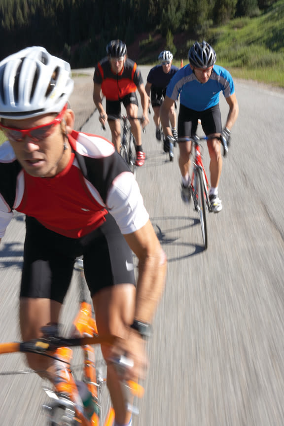
Image: Jack Affleck
It’s often said that the best way to see the world is from the seat of a bicycle.
During the all-too-brief seasonal interlude of sun-drenched summer days, when birdsong wafts on the thin air and alpine meadows bloom with wildflowers like colorful kaleidoscopes, that aphorism rings especially true in this corner of paradise. The Vail Valley, with a network of paved paths and rural roads transiting mountain passes and skirting the banks of snowmelt-swollen rivers and creeks, is the perfect place for anyone seeking a two-wheeled, full-sensory adventure.
Whether you’re a competitive road racer from the Front Range itching for a thigh-burning climb followed by a thrilling downhill plunge over Vail Pass or a recreational pedaler seeking a peaceful wend along the flats of the Eagle River, there’s a route that’s perfect for you. And if you’re fresh off the plane from sea level and getting your bike legs (and lungs) tuned to this elevation, consider a pedal-assist e-bike so you can focus on the views, instead of gasping for air. Could there be any better way to spend a day? Maybe by ending it at a local brewpub with craft beers, street tacos, and artisan pizza at sunset. We’ve got you covered there too.
Plus: E-Bike Curious? Here's Everything You Need to Know
The Classic Routes
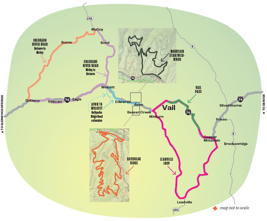
Vail Pass
Difficulty: Hard
Time: 1-2 hours
Miles: Approx. 14 miles depending on starting point
Elevation gain: 2,780 feet
Ascending and descending Vail Pass is a notorious rite of passage for cyclists of all persuasions (and the occasional longboarder channeling Ben Stiller’s Icelandic antics in The Secret Life of Walter Mitty). Snaking alongside I-70, this ever-steepening, nearly 9-mile (one-way) paved path climbs nearly 2,000 feet from Vail Village to the pass summit. If the constant effort doesn’t leave you breathless, the alpine terrain and views will as you ascend into the Gore Range. Following the old Highway 6 right of way, the average grade is a manageable 3 percent but punches up to 30 percent at the steepest part.
To get there, park at Vail Village and ride a gently ascending 6.7 miles up the frontage road. For a more casual start, you can also hop on the Gore Valley Trail in Vail Village and enjoy the quiet paved bike path until it runs into the frontage road in East Vail. Pass through the gate at Gore Creek campground and leave car traffic behind as you funnel onto the sustained grind of the bike path’s relentless incline. Pump those RPMs to chase the pro-cyclist Kings of the Mountain, or just keep your pedal strokes steady and enjoy the effort. At the 10,603-foot summit, you have two options: cruise down the other side to Copper or Frisco for lunch (and a bonus, though easier, climb back up), or turn around and settle in for the exhilarating descent into Vail that may just make you feel like you’ve earned your wings.
Leadville Loop
Difficulty: Hard
Time: 5-7 hours
Miles: 78 miles
Elevation gain: 6,000 feet
Whether you’re training for one of Colorado’s plentiful endurance races or just looking to tick off a classic alpine road tour, the Leadville Loop (also known as the Copper Triangle) delivers the miles (78), vertical feet (6,000), and ample natural and manmade attractions for a full-value ride. Whether it’s your bucket list season culmination or an every-other-weekend affair, the loop is a must-do for the dedicated cyclist.
Begin in Vail and head west on the Gore Valley Trail to Dowd Junction, where you’ll then head south on US 24 along the Top of the Rockies Scenic Byway. Pause at Vail Mountain Coffee and Tea (vailcoffee.com) for a caffeine boost before you pedal down Minturn’s quaint Main Street and begin the gradual climb up Battle Mountain Pass to the ghost town of Gilman and stop at one of the many pull-offs to appreciate waterfalls plummeting into the adjacent valley. Cross the iconic Red Cliff Bridge (the state’s only cantilevered steel arch bridge) suspended high above the Eagle River, then wind downhill to the state’s newest national monument, Camp Hale, a World War II-era historic site where 10th Mountain Division ski troopers trained in hardy, high-altitude conditions. From there, you’ll crest Tennessee Pass (10,424 feet), before rolling into Leadville, the highest (at 10,152 feet) incorporated city in the United States. Leadville proudly retains its mining legacy, as evidenced by the Climax Mine, which you’ll see once you turn north on Highway 91 and climb to the route’s high point at 11,340-foot Fremont Pass. Enjoy the stunning view of Clinton Gulch Dam Reservoir on the fast descent to Copper Mountain, where you’ll pick up the bike path to climb over Vail Pass for the final reward of coasting back to Vail. Don’t want to go it alone? Register for the Copper Triangle (theridecollective.com/coppertriangle), a supported ride on August 3.
Daybreak Ridge
Difficulty: Hard
Time: 1-2 hours
Miles: 12 miles
Elevation gain: 2,000 feet
Like virtually all routes out of the Vail Valley, this 12-mile loop involves a stout climb—in this case a 2,000-vertical-foot purgatory over 5.5 miles that humbled cyclists in the 2013 USA Pro Cycling Challenge. But from the circuit’s heavenly high point, where you overlook the soaring peaks of the Sawatch Range, you’ll hardly begrudge the effort. And because the ride takes place within gated neighborhoods, you’re more likely to spot deer than cars.
Start in Avon, wind around the roundabout at Highway 6, then crank up Village Road, passing through the gated main entrance to Beaver Creek Resort. The fluttering flags of various nations that raced in the 1999 and 2015 FIS Alpine World Ski Championships line the first hill and provide a welcome distraction from the effort. At 1 mile, turn right onto North Holden Road and admire the eerily dark multimillion-dollar vacation homes along the road. Follow Borders Road to Strawberry Park Road and ride past the gate that bars auto traffic from the tony Strawberry Park development where President Gerald R. Ford once owned a home. After you pass beneath the Elkhorn ski lift, pick up Daybreak Ridge Road to top out at a high point affording views down into both Beaver Creek and Bachelor Gulch. At sunset, the steely peaks soften in a wash of rosy, golden light. Follow Daybreak Ridge Road as it serpentines down through Bachelor Gulch (another gated community where vehicular traffic is limited to homeowners and a handful of shuttle buses), then cruise back into Avon via Highway 6.
Avon to Wolcott
Difficulty: Easy
Time: 1-2 hours
Miles: 22 miles
Elevation gain: 900 feet
Not all rides need to be test pieces. The Avon-to-Wolcott route is a pleasant 22-mile out-and-back with 900 feet of elevation gain that skirts the south bank of the glimmering Eagle River.
Pick up the Eagle Valley Trail in Avon and follow the paved recpath to Miller Ranch Road in Edwards, where you’ll hop onto Highway 6. Follow a somewhat generous shoulder and smooth tarmac, and pedal alongside the river as the valley landscape transitions from the verdant links of the Eagle Springs Golf Club to high ridgelines of red rock and undulating hills of semi-arid scrubland. Once you reach the sleepy hamlet of Wolcott, you can either turn back the way you came or cross under the interstate and grind up Bellyache Ridge Road to a promontory offering a raptor’s-eye view of the valley and the river and highway undulating east out to the Gore Range—where local paragliders leap into the wild blue yonder.
Mountain Star/Wildridge
Difficulty: Hard
Time: 2+ hours
Miles: 11 miles
Elevation gain: 2,000 feet
You don’t have to be in the one percent to enjoy the views of Mountain Star, a gated community high above Avon. All you need is legs and lungs strong enough to crank out the 1,900-foot climb that reaches a maximum grade of 26.5 percent.
From Avon, follow Nottingham Road to Buck Creek Road, where, just past Walking Mountains Science Center, your ascent begins. Climb the quiet, staggeringly steep switchbacks to the road’s pinnacle, where you can take in the panoramic views of Beaver Creek and the craggy ridgeline of New York Mountain beyond. At the gates blocking access to Mountain Star, an exclusive enclave with stratospheric home prices (at press time, the three properties for sale here ranged from $7.1 million to $11.5 million), turn left onto West Wildwood Road, and enjoy a two-mile mostly downhill coast to Metcalf Road, where your next climb begins. Turn right. Just after the switchback over the road’s namesake creek, it becomes West Wildridge Road. After a two-mile uphill grind through the Wildridge community, the pavement tops out and becomes East Wildridge Road as it loops downhill for 2.3 miles to intersect with West Wildridge Road. Turn left, then plunge around the switchback and back onto Metcalf Road. At the stop sign at the bottom of the hill, turn left onto Nottingham Road. Pass Buck Creek Road where you started, and park your ride at Northside Kitchen (thenorthsidekitchen.com), where a bearclaw or two awaits—you’ve earned those calories!
Colorado River Road
Difficulty: Moderate to hard
Time: Varies
Miles: 35 miles from Dotsero to Hwy 131/McCoy, 45 miles from McCoy to Dotsero
Elevation gain: 1,600 feet from Dotsero to McCoy, 1,600 feet from McCoy to Wolcott
There’s no finer way to escape the bustle of I-70 than with a pedal out Colorado River Road. Accessed from Dotsero, this rural thoroughfare transits sagebrush hills and canyons alongside the many rapids of the Upper Colorado River. Used mostly by ranchers, rafters, and anglers, the lonely road also parallels a railway where coal trains occasionally rumble.
Roughly 8 miles in, the pavement turns to hardpack dirt and gravel that is manageable for most road tires, though you’ll want to bring a pump and patch kit just in case. It’s 35 miles with a few short climbs before the road meets Highway 131 and the blink-and-you’ll-miss-it unincorporated Town of McCoy, but you can turn around whenever it suits you.
Or continue south for 20 miles along Highway 131 through Bond and then back on pavement to the rafting mecca of State Bridge with another climb followed by a long and windy descent through a gorgeous Frederic Remington Wild West landscape painting to Wolcott, where you can pick up Highway 6 and head west to a connector with a recently completed 22-mile stretch of the Eagle Valley Trail and follow the Eagle River on a gentle downhill glide back to its confluence with the Colorado River in Dotsero. In midsummer, start early to avoid the heat of the day, or plan to stop at one of the many river pull-offs for a picnic and a dip in a snowmelt-fed eddy.
Also Try
Want the thrill of Vail Pass without the uphill agony? Bike Valet, Charter Sports, Vail Bike Tech, and Venture Sports offer guided and self-guided downhill plunges on rental bikes (as well as personal bikes) from the top of Vail Pass to Vail Village, Lionshead, Cascade Village, and Avon; shuttles operated by these outfitters leave daily from multiple Avon and Vail locations throughout summer.