There's no end to the biking options in the valley—the hardest part is knowing where to start. We've mapped out some of the best routes for riding on-road or off.
Perhaps it’s the puffy white clouds painted high in cobalt skies, vast forests of effervescent pine and playful aspen, and countless meadows bursting with the colors of wildflowers. Or maybe it’s the lung-busting climbs, hair-raising descents, and jaw-dropping vistas from a network of scenic highways, recreation paths, and backcountry trails. In any case, exploring the Vail Valley in summer and fall, on the road or off, is a dream come true for a growing number of cyclists—from novices to longtime enthusiasts, families with kids to competitive two-wheelers on a mission. Spectacular scenery, challenging mountain terrain, and near-perfect weather make for some terrific riding. And with the professional peloton coming through for a spin in August, the word is getting out. Here’s how to get the most out of your time here on two wheels.
An extensive network of old logging and mining roads, ski-resort access roads, and well-maintained single-track trails provide an infinite selection of challenging but non-technical opportunities for exploring the Vail Valley. Here are three local off-road favorites.
MidValley Madness
AVON-EASY
Distance 14 miles
Elevation gain 1,656 feet
Max elevation 8,292 feet
Start/finish Beaver Creek’s Elk parking lot in Avon
Intermediate riders can rip up the single track on Avon’s Red Tail Ripper.
Recreational mountain bikers looking for a variety of nontechnical terrain on usually well-maintained dirt roads should relish the south-facing, sagebrush-covered slopes above Edwards and Avon, which typically are sunny and wide open, offering panoramic views of Beaver Creek and Arrowhead Resorts and the spectacular Sawatch Range. Once on the gravel Berry Creek Road, enjoy the scenic, two-climb traverse east to June Creek Road, then a third, relatively gentle climb up into the Wildridge neighborhood. On pavement again, enjoy the fast, smooth plunge down Metcalf Road to Nottingham Road and the valley floor, where you can cruise through Avon’s five roundabouts.
Directions: Park at Beaver Creek’s Elk lot and head west on Highway 6 on paved roads past the Singletree neighborhood for 4.5 miles to the gravel Berry Creek Road, just past the Shaw Regional Cancer Center. Enjoy the scenic, two-climb traverse east for 8.8 miles to June Creek Road. Go left and north, then right at 9.1 miles for a third climb up into the Wildridge neighborhood. On pavement again, ride east along Old Trail Road to a right turn on Wildridge Road, which becomes Metcalf Road. Turn left onto a bike path along Nottingham Road, then right on Avon Road to where the ride started.
RED TAIL RIPPER
AVON-EASY-MEDIUM
Distance 14.1 miles
Elevation gain 1,994 feet
Max elevation 8,844 feet
Start/finish Beaver Creek’s Elk parking lot in Avon
Ready to head up higher and take on some single track? This intermediate ride, primarily through majestic aspen and pine forests on both paved and dirt roads and trails, visits the upscale Arrowhead and Bachelor Gulch communities and Beaver Creek Resort’s Red Tail Camp area.
The Village-to-Village Trail from there is a smooth, wide ride—on a blanket of aspen leaves in autumn—all the way to its intersection with the Beaver Lake Trail, followed by the thrilling, gravel descent along Beaver Creek’s namesake stream to pavement again at Elk Track Road and Beaver Creek Village. Finish with a fast and smooth descent on Village Road to Avon.
Directions: Beginning at Beaver Creek’s Elk parking lot, head west 2.2 miles along Highway 6 to Arrowhead, turn south and climb the paved Cresta Road to the Trailside neighborhood. At 4.8 miles, turn right onto gravel and follow the Village-to-Village Trail all the way to its intersection with the Beaver Lake Trail, at 10.2 miles. Turn left and begin the gravel descent along Beaver Creek to pavement at Elk Track Road and through Beaver Creek Village, continuing down Village Road to Avon.
EAGLE’S NEST TEST
VAIL MOUNTAIN-MEDIUM-HARD
Distance 13.1 miles
Elevation gain 2,205 feet
Max elevation 10,340 feet
Start/finish Eagle Bahn Express gondola in Lionshead
For the real climbers among us who love lung-busting ascents to the highest reaches of road or trail, the long, steady climb to Eagle’s Nest, 10,340 feet above sea level on top of Vail Mountain, lives up to its name. Once on the mountain, settle in for the scenic clamber on dirt and gravel access roads through the pine and aspen forests past Golden Peak, Northwoods, and MidVail. At the top, enjoy panoramic views of Vail, the Gore Range, and the Mount of the Holy Cross. Options for the descent include heading back down Village Road, the fastest and smoothest ride; descending the steeper and rougher Getalong Road, instead, for a loop; or, if you’ve had enough time in the saddle, simply waving yourself aboard the gondola for a scenic, relaxing trip downward.
Directions: Beginning at the Eagle Bahn Express gondola in Lionshead, head south to Forest Road, then left and up to Village Trail, at 0.6 miles, then prepare for the steady, 7-mile climb to Eagle’s Nest, at the top of the mountain. Options for the descent, other than the gondola, both start out by heading back down Village Road. Either follow the road all the way back down, or make a left at 8.7 miles and descend Getalong Road instead.
Majestic views of the Mount of the Holy Cross are the reward for summiting Vail Mountain on the Eagle’s Nest test ride.
HIT THE ROAD
The Vail Valley’s uncrowded recreation paths and smooth, scenic highways make riding the open road along roaring rivers and streams, through glacier-carved valleys, and over major mountain passes an experience not soon forgotten. Try these rides on for size.
TOUR DE VAIL
VAIL-EASY
Distance 19.8 miles
Elevation gain 883 feet
Max elevation 8,618 feet
Start/finish Stephens Park in West Vail
Start from anywhere in Vail Village or Lionshead, and all roads lead to the Tour de Vail.
Are great scenery and off-the-bike diversions higher on your priority list than the intensity of your workout? One of Vail’s easiest (and flattest) scenic road rides passes by many of town’s renowned, kids-centric parks, perfect for taking breaks or enjoying a picnic lunch. Thoughtfully designed signs help you follow the undulating creekside path as it travels the length of town, from west to east, passing by quintessential Vail scenes in Lionshead and Vail Village and their parks. It then wends its way through East Vail, where Bighorn Park offers up-close and personal views of the highest peaks of the Gore Range. Retrace the route, or make a loop of frontage roads to return to West Vail.
Directions: Starting at Stephens Park in West Vail, head east on the South Frontage Road to Gore Creek Drive, at 0.84 miles. Look for the Gore Valley Trail, beginning at Donovan Park, at 1.3 miles. Follow the creekside path through Cascade Village, Lionshead, and Vail Village before heading up along the Vail Golf Course to East Vail, where the ride makes a lap of the neighborhood on Lupine, Columbine, and Meadow Drives. Take a break at Bighorn Park, at 9.6 miles, before the downhill return trip on Bighorn Road and the North Frontage and South Frontage roads back to West Vail.
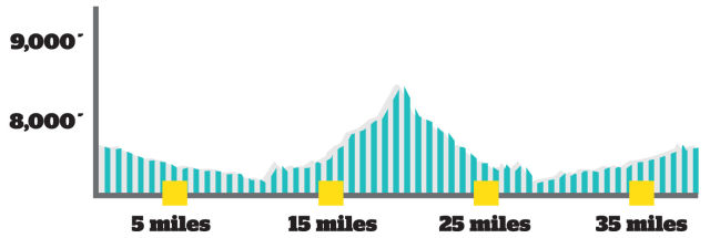
THE DIVIDE RIDE
AVON-MEDIUM
Distance 38.7 miles
Elevation gain 2,023 feet
Max elevation 8,261 feet
Start/finish Beaver Creek’s Elk parking lot in Avon
Intermediate road riders looking for some long, sometimes steep grades—and great scenery—but not quite ready to tackle the high passes should head west and north to the wide-open plateaus north of Wolcott. The ride starts in Avon with a gentle downhill heading west through Arrowhead and Edwards and along the scenic Eagle River to Wolcott. There, climbing begins abruptly on northbound Colo. 131, a Scenic Byway. Take a break at 4 Eagle Ranch, perhaps, before pushing on to the top of the Wolcott Divide, the seasonal home to Basque shepherds, where you can take in sweeping views of the Sawatch Range to the south and parts of the Gore Range to the north and east. Turn around and enjoy the fast and furious descent back to Wolcott—and another break—before the relatively gentle, 11-mile ascent east back up the Eagle River Valley to Avon.
Directions: Starting at Beaver Creek’s Elk parking lot in Avon, head west on U.S. Highway 6 through Arrowhead and Edwards and along the Eagle River to Wolcott, at 11 miles. Turn right and start climbing north on Colo. 131 and push on to the top of the Wolcott Divide, at 19.4 miles. Turn around and enjoy the fast and furious descent back to Wolcott. Turn left on Highway 6, at 28.0 miles, and return to Avon.
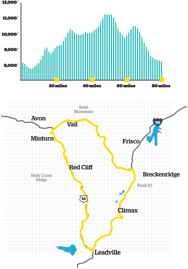
LEADVILLE LOOP
MINTURN-HARD
Distance 78 miles
Elevation gain 6,045 feet
Max elevation 11,340 feet
Start/finish Forest Service headquarters parking lot in Minturn at Dowd Junction
Even bikes need a break at the highest point in the Leadville Loop.
For diehard road cyclists in top shape and rarin’ to go for the high passes, one of the most popular and challenging rides is the Leadville Loop, an epic, 78-mile adventure that twice passes over the Continental Divide, providing some of the most awe-inspiring mountain scenery in North America. With four passes along the way, the climbs are demanding, but the descents are well worth it. Between Minturn and Leadville, highlights include the spectacular Red Cliff Bridge over the Eagle River, Battle Mountain Pass (9,267 feet), and Camp Hale and the 10th Mountain Division Memorial on Tennessee Pass (10,424 feet). Between Leadville and Copper Mountain, top out at the Climax Mine on Fremont Pass (11,340 feet), and take in the breathtaking Clinton Gulch Dam Reservoir while descending to Copper Mountain. From there, climb to the crest of Vail Pass (10,554 feet) on the bike trail before a well-earned descent back into the Vail Valley. Veterans of The Loop say it’s “easier” ridden counter-clockwise as described here, climbing Fremont and Vail Passes on their gentler sides; if you’re looking for more challenge, ride the loop clockwise.
Directions: Starting at Beaver Creek’s Elk parking lot in Avon, head west on U.S. Highway 6 through Arrowhead and Edwards and along the Eagle River to Wolcott, at 11 miles. Turn right and start climbing north on Colo. 131 and push on to the top of the Wolcott Divide, at 19.4 miles. Turn around and enjoy the fast and furious descent back to Wolcott. Turn left on Highway 6, at 28.0 miles, and return to Avon.
Local options abound for renting the perfect two-wheeler and essential gear, including a helmet:
Vail:Just a couple pedal strokes from the Eagle Bahn Express gondola in Lionshead, Bike Valet offers a wide range of mountain, road, and hybrid bikes. Half-day, full-day, and bike repairs offered. 970-476-7770; https://www.bikevalet.com/
Eagle-Vail Colorado Bike Service, on U.S. Highway 6, offers Colnago and Bianchi road bikes and Cannondale and Santa Cruz mountain bikes by the day or by the week. 970-949-4641; coloradobikeservice.com
Beaver CreekBeaver Creek Sports, in Beaver Creek Village and at the Westin Riverfront Resort in Avon, offers mountain bikes, junior bikes, and cruisers by the half-day or full-day. Beaver Creek rentals: 970-754-6221; Avon rentals: 970-748-3080; https://www.beavercreeksports.com/bike-rentals/
For the best High Country cycling experience possible, why not let someone else do the planning, preparation, and support? On the bike and off, you’ll be glad you did.
Take the High Road: If you have a passion for high mountains and dramatic scenery, buttressed by gourmet meals, High Road Velo Tour’s inaugural adventure, the Tour of the Rockies, is right up your alley. Featuring 185 miles of spectacular roads and 115 miles of traffic-free recreation path to the highest reaches of North America’s Continental Divide, this five-day, six-night, 300-mile, self-guided, fully supported tour is a unique opportunity to explore the heart of one of the world’s great mountain ranges while enjoying everything its world-class resort towns have to offer. Highlights on the bike include Glenwood Canyon, Independence, Hoosier and Vail Passes, South Park, and the shores of Dillon Reservoir. Off the bike, guests are treated to the finest accommodations available in Beaver Creek, Glenwood Springs, Aspen, Buena Vista, Breckenridge, and Vail. (High Road Velo Tour is owned by writer Stephen Lloyd Wood.) 970-306-8420
Head for the Backcountry: Mountain bikers looking for serious off-road adventure can count on Paragon Guides, a local company that’s been rolling out top-notch outdoor adventures throughout the region since 1978. From half-day and full-day guided tours of the surrounding mountains, to custom, vehicle-supported, multiday excursions employing the 10th Mountain Division Hut System and private guest ranches, there’s no better way to explore single-track paths, jeep trails, and historic logging and mining roads in the High Country while enjoying the comforts of an alpine hut. Along with Paragon’s three-day 10th Mountain Traverse trip, the company offers a 100-mile, five-day Holy Cross 100, which circumnavigates the Holy Cross Wilderness at altitudes of more than 12,000 feet above sea level. Reservations:970-926-5299; Retail & Rentals: 970-827-5363.
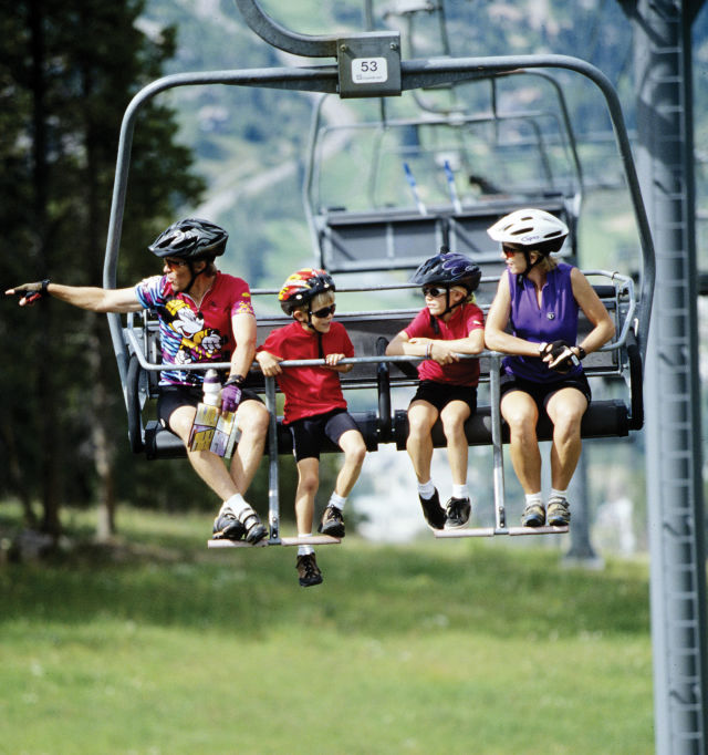
Got Kids?
Opportunities to ride safely, at a slower pace and away from traffic, abound in the Vail Valley, a resort community known for its family-oriented attractions, services, and activities. Here are some options for you and your kids.
Kids fit the picture in the Vail Valley’s biking scene.
Camps and Workshops: Based at Golden Peak in Vail, Vail Mountain Bike Camps offers a variety of programs for kids of all abilities and ages, from three-day camps that teach the basics of riding, safety, and maintenance, to a summerlong Junior Race Academy that builds mountain-bike racing skills. Other programs include Women’s Weekends and Women’s Skills Workshops. Private and group lessons also available. 970-470-3431, vailmountainbikecamps.com
Private Tours: Don’t let the name fool you. The Beaver Creek Hiking Center has more on tap than hikes. Hop in the saddle for family-oriented, half-day, and full-day mountain-bike tours of both Beaver Creek and Vail Mountains. Professional guides who are knowledgeable about local flora, fauna, history, and geology—as well as trained in first aid and CPR—plan custom outings based on your family’s ability and experience. Various packages include wine excursions, lift access, and picnic lunches. 970-754-5373, beavercreek.com
Lift-served Rides: Love the downhills but not the uphills? Put yourself and your bike on the lift. Both Vail and Beaver Creek offer bike-haul service to the top of the mountain throughout the summer via the Eagle Bahn Express gondola and the Centennial Express chairlift, respectively, for some of the best downhill mountain biking in North America on a variety of ability-rated trails. Various packages can include day passes, bike rentals, and vouchers for a scenic outdoor lunch at Eagle’s Nest or Spruce Saddle.vail.com; beavercreek.com