Trail of the Week: Mount of the Holy Cross
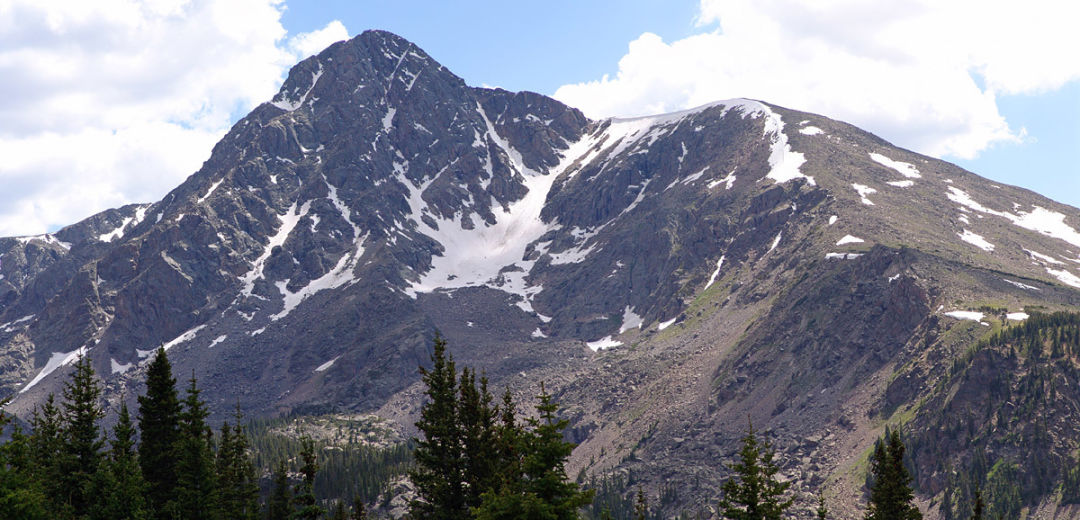
Mount of the Holy Cross, with the North Ridge on looker's right.
Image: 14ers.com
From any vantage point in the valley, Mount of the Holy Cross towers high above the rest of Eagle County's plentiful peaks, a 14,005 foot pinnacle of rock in the Sawatch range best known for its crucifix of snow plastered to the mountain's northeast face. It might be Eagle County's only 14er — a term given to Colorado's 58 peaks over 14,000 feet in elevation — but it's one of Colorado's toughest, a challenging climb for even experienced hikers, with two routes deemed as Class 2 (a difficult hike that requires scrambling over talus and scree as well as some route-finding: the North Ridge — the traditional 12.5-mile route— and Halo Ridge—a 15-mile roundtrip scramble for experts only) and one Class 3 (unroped scrambling climbing over steep and extreme terrain: Cross Couloir — a near-vertical ascent up the snow cross) for anyone attempting to summit. The sheer mileage required to summit Holy Cross makes it an ill-advised first ascent for those new to hiking 14ers, but if you have a bit of experience under your belt, are in tremendous physical shape, and are looking for a longer out-and-back to summit, standing atop one of the state's most iconic 14,000 foot peaks is other-worldly, with the Maroon Bells, Mount Massive, and Mount Elbert all visible from the top.
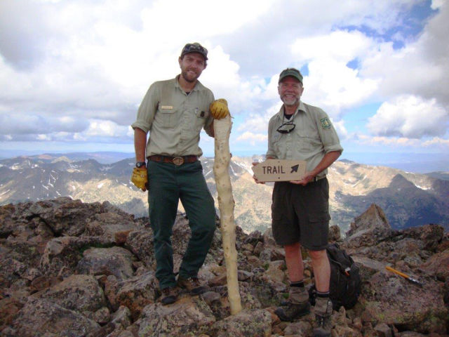
USFS Wilderness & Trails Manager Mike Beach and Mount of the Holy Cross Lutheran Church pastor/USFS Volunteer Ranger/Vail Mountain Rescue Group board member Scott Beebe, with the sign they hiked up the mountain and installed at the summit on July 28, 2017, directing hikers to the correct trail down, a public safety project that has been years in the making.
The Route
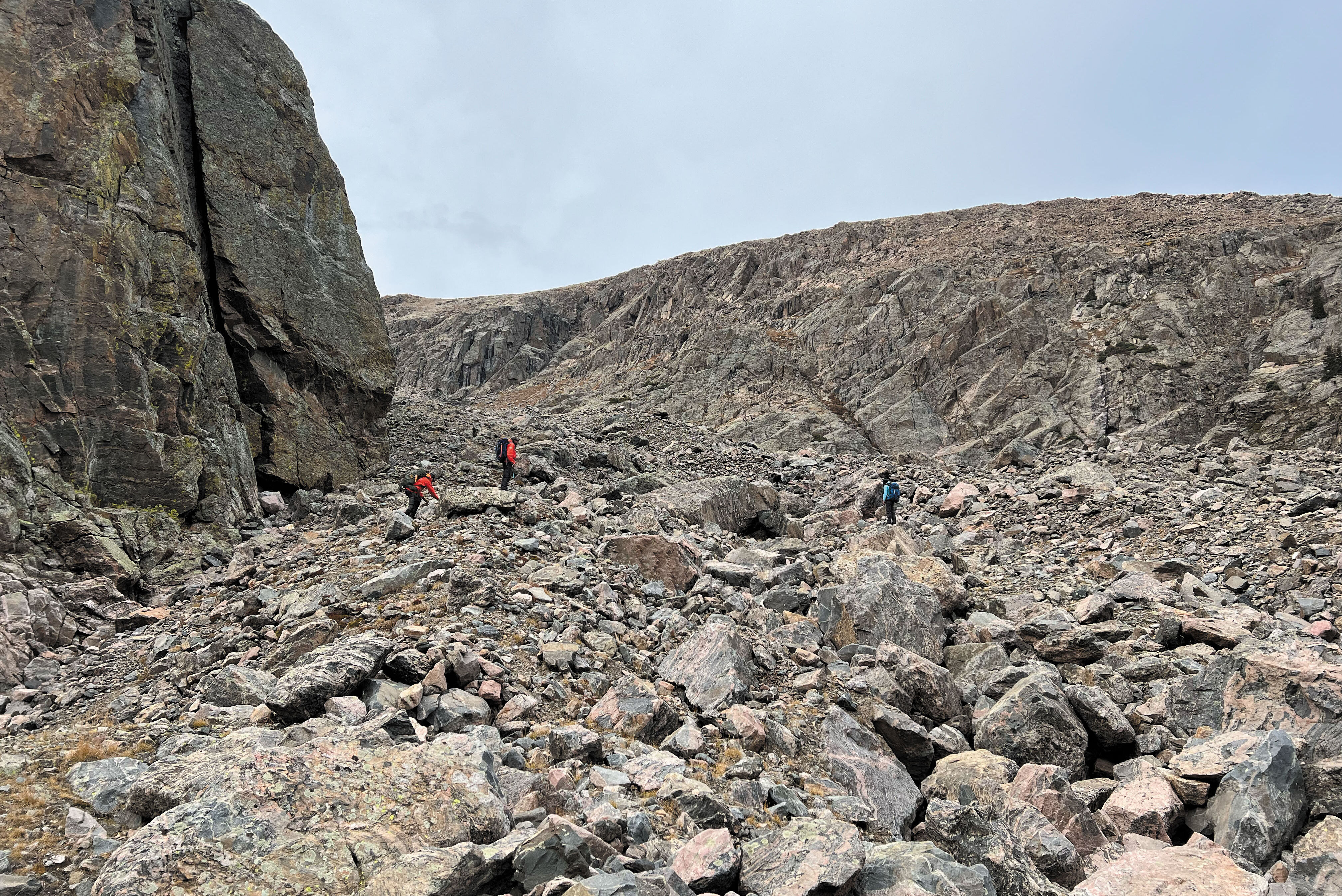
Mount of the Holy Cross's North Ridge is the traditional route to summit the peak, and by far the most popular option with most hikers. Popularity doesn't always equal ease, however. The North Ridge still requires hikers to trek 12-miles round trip and conquer 5,600 feet in elevation gain — with a 1,000 foot climb required near the end of the trail to get back to the trailhead. The route itself begins by ascending Half Moon Pass, with Notch Mountain, a neighboring 13er, off to the east. Once atop the pass, the path descends with Holy Cross and much of the trail visible to the southwest before hikers come to East Cross Creek at the bottom of their descent. At this point the trail climbs again — steeply — as it works its way through pines before reaching treeline, where it then opens to a talus field with cairns marking the route. The trail continues to scramble through scree and talus as hikers near the North Ridge, with the last 300 feet considered the crux of the climb (the steepest section of scree, with a bit a route-finding needed to navigate the top section). Cairns mark the path along the way, although signage was added during the summer of 2017 to help steer hikers in the right direction, and avoid the oft-made mistake of following the fall-line from the summit into the Cross Creek drainage, and a long-cold night awaiting rescue. That's another sobering reminder that Mount of the Holy Cross, a hike that's on the bucket list of Colorado peak baggers, isn't just another walk in the woods.
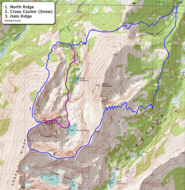
Image: 14ers.com
Quick Facts
- Trailhead: Half Moon Campground via Tigiwon Road (#707)
- Starting Elevation: 10,320 feet
- Summit Elevation: 14,005 feet
- Roundtrip Distance: 12 miles
Trailhead
From I-70, take Exit 171, and follow U.S. 24 through downtown Minturn for about 5 miles before turning right onto Tigiwon Road. Half Moon Trailhead is located at the end of the dirt road (nearly 9 miles in length).
Camping
Camping is available on a first-come-first-served basis at the Half Moon Campground, although the 11 sites can fill up quickly (especially on weekends). Primitive camping is also available on the trail at the end of the descent from Half Moon Pass near East Cross Creek, although no campfires are allowed at these sites, and campers should read through the rules and regulations on the area's signage.
Dogs
Even if your pooch is trail-tested and has the stamina for an endurance hike, be kind and leave Fido behind. Above treeline, there is no shade or water, and on a cloudless day, heat exhaustion can take its toll. Also, sharp rock edges on the scree and talus scramble to the summit can be brutal on paws, and can hobble your pet miles from the trailhead. Bottom line: Even though they are allowed, this is not a suitable trail for dogs. If you still think your pooch can tackle this trail, at a minimum, carry plenty of extra water, a canine first aid kit, and boots for the summit scramble.
Backpack Must-Haves
- Water (carry more than you think you will need: again, there is no water above treeline)
- Sunscreen
- Layers (an insulating jacket, a water-resistant outer layer, and cold weather gear like gloves and a hat are all advised, even during the summer)
- Headlamp, and extra batteries
- GPS/compass
- Cell phone with a fully charged battery, and ideally a secondary power source (in case you need to call or text for help; since reception can be spotty, do not rely on your cell phone for navigation)
- Food
- Map (we recommend this one)
- Fire starter
- First aid kit
- Rule of thumb: Carry what you would need to spend a night out on the mountain, even if you don't anticipate doing so
Weather
Even on a hot sunny summer day in the valley, the weather above treeline can approximate fall or winter conditions—snow in August or September is not uncommon. Be prepared, and check the forecast before you leave for the trailhead; we recommend this app, which gives up-to-date weather data for every Colorado 14er peak. Even if you've been planning your summit day for weeks, if rain/wind/lightning/snow are in the forecast, wave off, and live to hike another day.
Additional Considerations
When contemplating any hike that tops out at over 14,000 feet, 14ers.com should be your go-to reference for up-to-date trail information; the site includes all the basics, including maps, a comprehensive photo database documenting each route turn-by-turn, and equipment and safety tips. When attempting to summit, the earlier start the better (6 a.m. is typically the latest that's recommended), as hikers should be coming off the summit no later than noon to avoid the hazard of afternoon lightning storms, and to return to the trailhead before nightfall. Also, leave a detailed itinerary of your planned hike with a responsible friend or relative, and ideally a note on the dashboard of your vehicle at the trailhead (including your name, phone number, number in your party, equipment you are carrying, the time you intend to leave the trailhead, which route you are taking, and the time you plan to return to the trailhead), in case something happens out there and you need assistance from our local search and rescue team. For more information: Search for "Mount of the Holy Cross" at fs.usda.gov